By: Joe Arrowsmith, PE, Water Resources Engineer
What is a two-dimensional hydraulic model?
And how can it make my bridge, stream, wetland, or floodplain project better?
At Straughan, we are taking our design projects to the next dimension! Our water resources engineering team relies on cutting edge 2D models to visualize the movement of water. But what does this mean? And how can it improve your project?
What’s the difference between a one-dimensional and a two-dimensional model?
We use models to describe the movement of water through space. In the physical world, a drop of water can move in three dimensions:
- Forward and backward – For example, along a river, this would be the upstream to downstream direction.
- Side-to-side – Let’s imagine that a river flows right up to the brim of its banks and water begins to spill out away from the channel. This is an example of side-to-side flow.
- Up and down – Imagine a fountain, or a geyser pushing water upward!
A water resources engineer uses physics equations to describe the moment of water. To keep the math simple, we often assume that the vast majority of the water is moving in only one dimension ― upstream to downstream. Models that depend on this assumption are “one-dimensional models”.
In very simple situations, an engineer can solve a one-dimensional problem with a pencil, a calculator, and a cup of coffee. We use computer models to help with more complicated situations. One of the most popular and free one-dimensional models is the U.S. Army Corps of Engineers HEC-RAS software.
A one-dimensional solution is perfectly fine for many situations. But if a significant portion of the water is not moving from upstream to downstream, our assumption fails. This means that our results may not be giving us a great representation of what’s going on. That is a big deal when you’re trying to protect roads, buildings, and bridges from flooding!
Two-dimensional computer models give us a new tool to better understand flow that moves in more than one direction. Until relatively recently, two-dimensional models required enormous amounts of computing power and a LOT of time to deliver results. But advances in computer technology have made two-dimensional modeling a fast, inexpensive, and invaluable tool for planning and design. At Straughan, we rely on several different pieces of software for two-dimensional modeling including the recently released HEC-RAS 2D module, SRH-2D, and ADCIRC.
When should I use a two-dimensional model?
You can use a two-dimensional model for equal or better output whenever you would have used a one-dimensional model. But here are a few areas where we have found that 2D models add special value to our services:
Bridge analysis
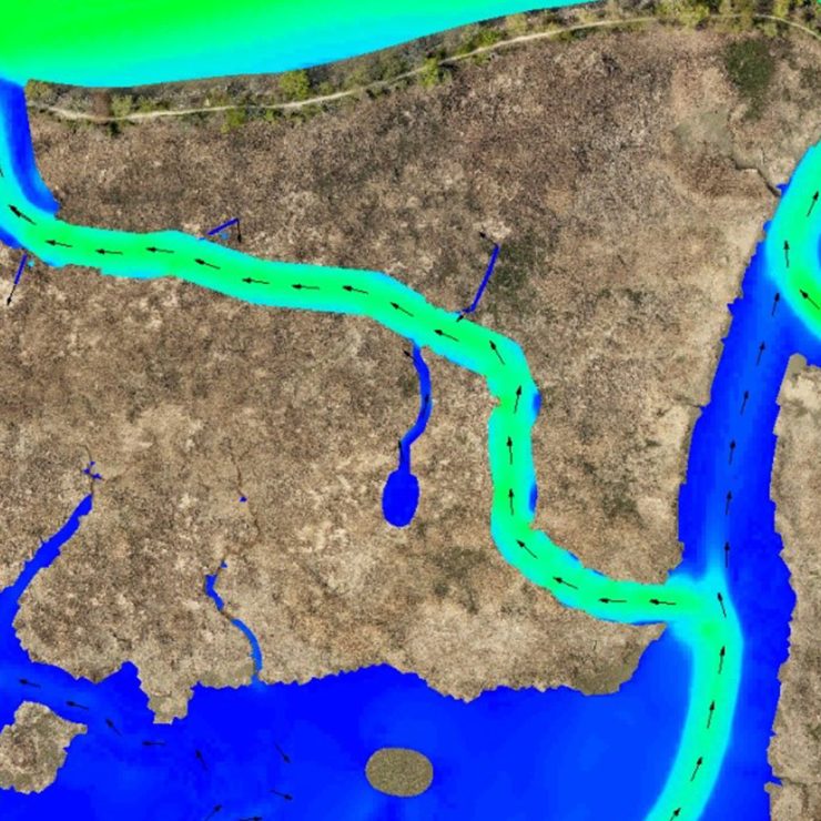
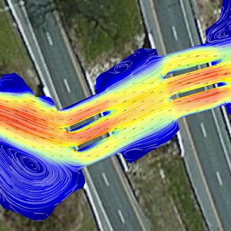
Here in Maryland on the shores of the Chesapeake Bay, we experience tidal influence. Our two-dimensional models allow us to analyze how bridges behave when flow from upstream meets a constantly changing tide. The most severe event a bridge faces may not be a large flood from upstream. It could be the quick draw down of tidewater that follows storm surge flooding from a hurricane. A two-dimensional analysis can help the designer narrow down their most critical design “event” and ensure the foundation of the bridge is safe from harm.
Stream restoration
When designing a stream to establish a more frequent connection with its floodplain, we need to understand what happens to the water as it spreads out away from the channel. Flow that moves across the floodplain is sensitive to minor changes in topography and slope. A 2D analysis helps us to understand where this irregular flow is too strong. Feedback from the model allows us to minimize the potential for erosion and maximize ecological uplift and function.
Wetland creation
Created, restored, or existing wetlands often find themselves at the intersection of surface and groundwater. A two-dimensional analysis helps us to understand how surface runoff, riverine flooding, and/or tidal exchange can influence wetland hydrology. Two dimensional analysis helps us to understand what happens when concentrated flow suddenly spreads out over a broad, flat wetland.
Flood hazard mapping and modeling
Two-dimensional modeling provides more detailed mapping and modeling of floodplain area, depth, and velocity than ever before. This detail can guide planners within flood prone watersheds on the safe placement of buildings and infrastructures. The visualizations and output from a 2D model can guide emergency responders and inform risk management. We can also efficiently model dam and levee breach scenarios to more clearly define areas at risk for flooding.
How do I learn more?
A great place to start is to visit the U.S. Army Corps of Engineers website to access the most recent HEC-RAS 2D software and try their example models: http://www.hec.usace.army.mil/software/hec-ras/
We’d love to hear more from you about how you use 2D modeling in your projects. Please feel free to connect with us on social media or by emailing info at straughanenvironmental dot com!